


| SOSTIENICI CON UN CONTRIBUTO VOLONTARIO |
| http://www.solaractivity.it/iscrizione/ |
Oggi 7 novembre 2017 l’ Europa è stata investita da una nuova tempesta geomagnetica di carattere minore rispetto alle precedenti del 31 agosto e 6-8 di settembre, vedi qui:
Tempesta geomagnetica del 31/8 – 2/9: http://www.solaractivity.it/2017/09/analisi-geomagnetica-2017-09-02/
Tempesta geomagnetica del 6/9 – 8/9: http://www.solaractivity.it/2017/09/analisi-geomagnetica-2017-09-08/
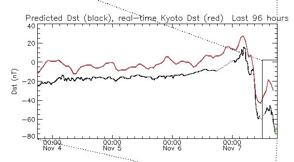
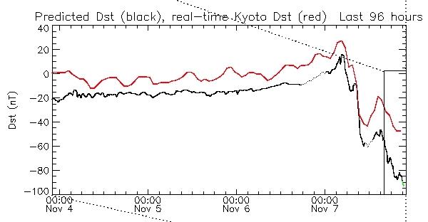
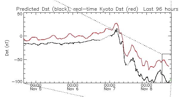
Nonostante questo l’ indice geomagnetico DST si è spostato di un differenziale notevole: da +30 nT a -45 nT con un differenziale complessivo di -75 nT.
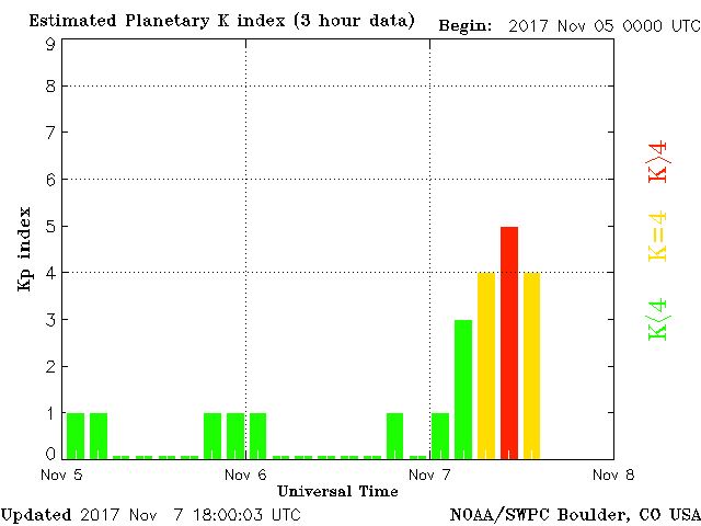
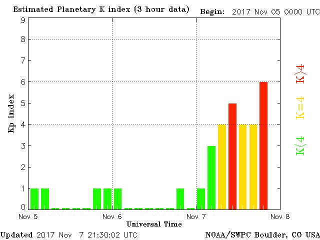
Questa cosa ha provocato una tempesta geomagnetica di classe G1
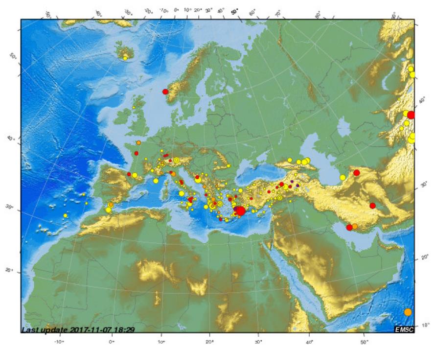
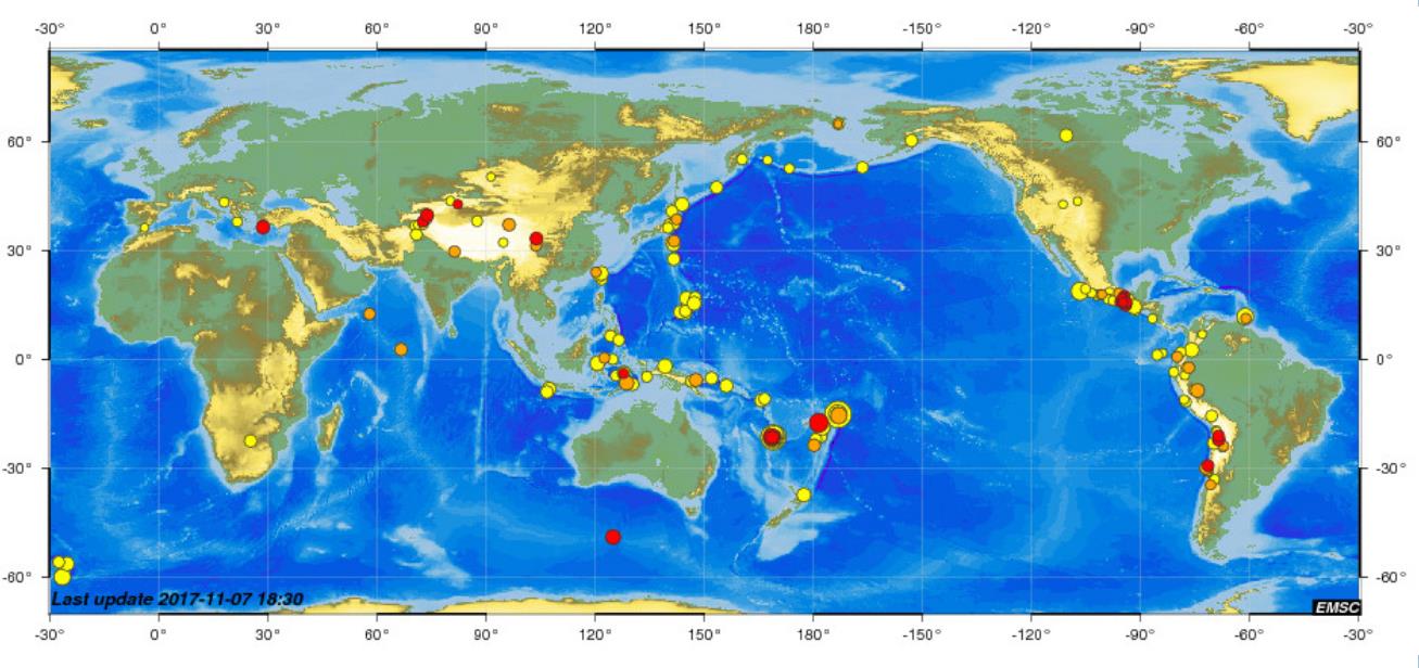
Ricordiamo che tutta l’ energia ricevuta dal 31 agosto al 2 settembre e quella ricevuta poi il 6-8 di settembre non si è ancora dissipata. E ricordiamo che fino a ieri l’ Europa e tutto il pianeta sono stati scossi da fenomeni importanti e ripetuti. Vedi l’ esempio qui sotto relativo a solo l’ ultima settimana.
Europa, ultimi 7 giorni
Mondo, ultimi 7 giorni
Pertanto questo accumulo ulteriore potrebbe scatenare fenomeni sisimici importanti ed improvvisi con un mix di fenomeni profondi (dovuti alle precendenti tempeste) e fenomeni entro i 10 km di profondità dovuti a queste nuove perturbazioni.
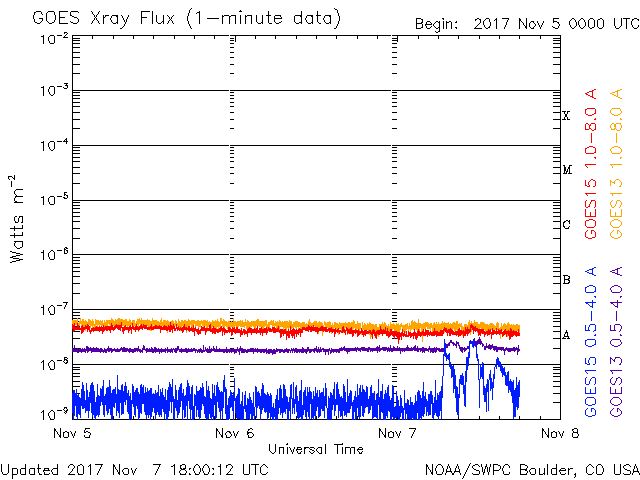
Aggiungiamo che nelle ultime ore si sta notando un incremento dell’ attività nella banda dei raggi X e questo potrebbe voler significare che il Sole si sta preparando a sparare contro di noi uno dei suoi potenti flare.
Sicuramente l’ Europa sta attraversando un periodo geomagnetico delicato da tenere in grande considerazione.
Update 07/11/2017 21:49 UTC

Situazione in rapida evoluzione. L’allerta viene esteso a tutto il pianeta dato che la perturbazione geomagnetica si è estesa. Zone particolarmente colpite saranno le americhe e il Pacifico, oltre, si intende, all’ Europa.
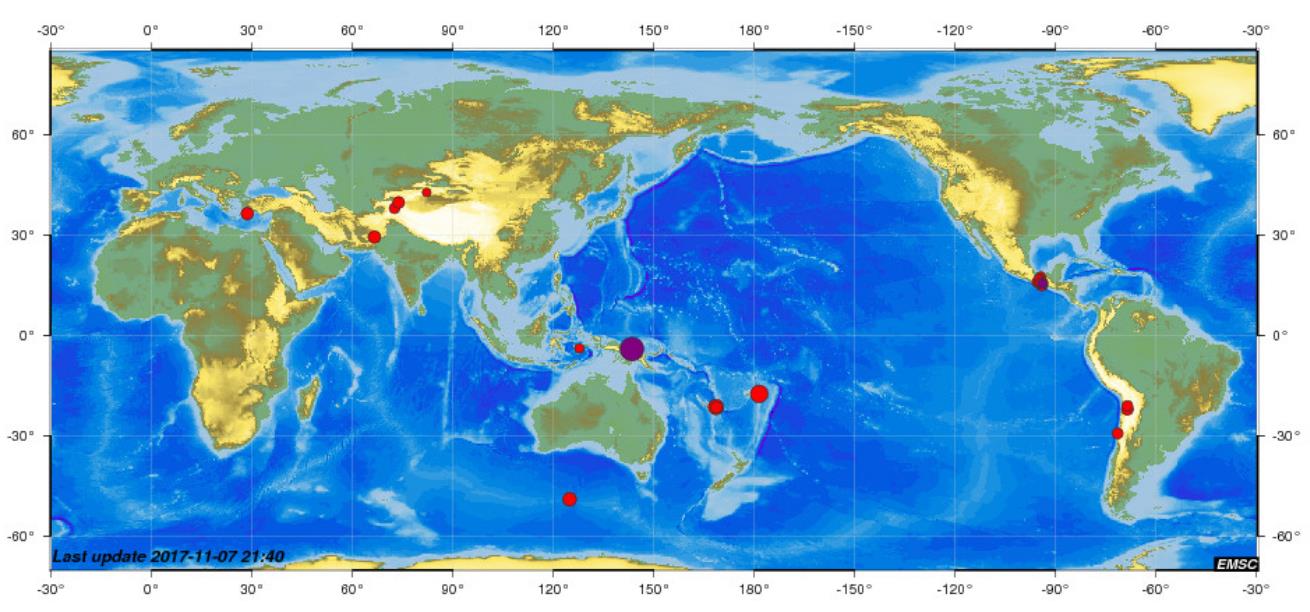
Segnaliamo il 6.6 a 113 km (media) di profondità appena avvenuto in Papua Nuova Guinea.
Magnitude Mw 6.5
Region NEW GUINEA, PAPUA NEW GUINEA
Date time 2017-11-07 21:26:39.1 UTC
Location 4.17 S ; 143.49 E
Depth 122 km
Segnaliamo inoltre un sisma molto particolare avvenuto molto vicino al supervulcano di Yellowstone il giorno 5 novembre e passato quasi del tutto inosservato ai media.
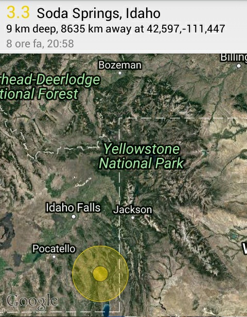
Magnitude ML 3.5
Region SOUTHERN IDAHO
Date time 2017-11-05 19:58:11.5 UTC
Location 42.58 N ; 111.42 W
Depth 8 km
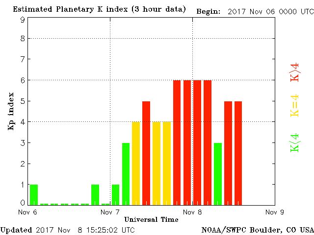
Update 08/11/2017 15:32 UTC
Secondo giorno consecutivo di tempesta solare che per diverse ore ha toccato la classe G2 Planetaria. Ieri e oggi su Europa una G1.
Indice DST come si vede in piacchiata ha sfondato più volte la soglia dei -50 nT. raggiungendo anche -70 nT.
Sismi dal 7 novembre fino al 21 dicembre 2017.
M 5.7 – 249km NNE of Chichi-shima, Japan
2017-12-21 03:00:19 UTC 29.286°N 142.720°E 16.2 km depth
https://earthquake.usgs.gov/earthquakes/eventpage/us1000bu46#executive
M 4.9 – 64km SSW of Palaiochora, Greece
2017-12-20 04:18:22 UTC 34.684°N 23.448°E 20.3 km depth
https://earthquake.usgs.gov/earthquakes/eventpage/us1000btgz#executive
M 4.8 – 90km SSE of Makry Gialos, Greece
2017-12-16 16:57:04 UTC 34.295°N 26.367°E 10.0 km depth
https://earthquake.usgs.gov/earthquakes/eventpage/us2000c58s#executive
M 6.5 – 0km ESE of Cipatujah, Indonesia
2017-12-15 16:47:56 UTC 7.734°S 108.023°E 91.9 km depth
https://earthquake.usgs.gov/earthquakes/eventpage/us2000c4v8#executive
M 6.5 – 82km WNW of Bouvet Island, Bouvet Island
2017-12-13 18:03:42 UTC 54.216°S 2.148°E 10.0 km depth
https://earthquake.usgs.gov/earthquakes/eventpage/us2000c3y6#executive
M 4.8 – 29km SSE of Palaiochora, Greece
2017-12-13 07:30:07 UTC 34.978°N 23.756°E 38.6 km depth
https://earthquake.usgs.gov/earthquakes/eventpage/us2000c3ru#executive
M 6.0 – 64km NNE of Kerman, Iran
2017-12-12 21:41:31 UTC 30.839°N 57.276°E 10.0 km depth
https://earthquake.usgs.gov/earthquakes/eventpage/us2000c3mi#executive
M 6.0 – 51km NNE of Kerman, Iran
2017-12-12 08:43:17 UTC 30.720°N 57.271°E 10.0 km depth
https://earthquake.usgs.gov/earthquakes/eventpage/us2000c3ag#executive
M 5.6 – 52km S of Sola, Vanuatu
2017-12-11 17:29:10 UTC 14.351°S 167.455°E 187.3 km depth
https://earthquake.usgs.gov/earthquakes/eventpage/us2000c2vg#executive
M 6.1 – 49km NW of Fais, Micronesia
2017-12-09 15:14:24 UTC 10.090°N 140.208°E 10.0 km depth
https://earthquake.usgs.gov/earthquakes/eventpage/us2000c2du#executive
M 5.7 – 29km SW of Hihifo, Tonga
2017-12-08 23:42:10 UTC 16.131°S 173.950°W 129.3 km depth
https://earthquake.usgs.gov/earthquakes/eventpage/us2000c286#executive
M 6.4 – 50km WNW of Fais, Micronesia
2017-12-08 09:51:10 UTC 10.009°N 140.132°E 20.3 km depth
https://earthquake.usgs.gov/earthquakes/eventpage/us2000c1zn#executive
M 4.5 – 23km WNW of Emponas, Greece
2017-12-08 05:20:41 UTC 36.311°N 27.614°E 10.0 km depth
https://earthquake.usgs.gov/earthquakes/eventpage/us2000c1yf#executive
M 5.9 – 104km NNE of L’Esperance Rock, New Zealand
2017-12-08 02:09:57 UTC 30.555°S 178.492°W 12.0 km depth
https://earthquake.usgs.gov/earthquakes/eventpage/us2000c1xc#executive
M 6.4 – 50km NW of Fais, Micronesia
2017-12-08 00:22:54 UTC 10.116°N 140.220°E 12.8 km depth
https://earthquake.usgs.gov/earthquakes/eventpage/us2000c1wt#executive
M 4.5 – 6km WSW of Grebocice, Poland
2017-12-07 17:42:50 UTC 51.582°N 16.072°E 10.0 km depth
https://earthquake.usgs.gov/earthquakes/eventpage/us2000c1p3#executive
M 5.8 – 149km S of L’Esperance Rock, New Zealand
2017-12-04 00:08:07 UTC 32.777°S 178.791°W 22.8 km depth
https://earthquake.usgs.gov/earthquakes/eventpage/us1000bkpn#executive
M 4.2 – 6km N of Amatrice, Italy
2017-12-03 23:34:11 UTC 42.683°N 13.308°E 3.3 km depth
https://earthquake.usgs.gov/earthquakes/eventpage/us1000bkp1#executive
M 3.0 – 1km SE of Marsaxlokk, Malta
2017-12-01 22:10:47 UTC 35.831°N 14.553°E 11.3 km depth
https://earthquake.usgs.gov/earthquakes/eventpage/us1000bk4u#executive
M 6.2 – 16km NE of Bahia de Caraquez, Ecuador
2017-12-03 11:19:05 UTC 0.490°S 80.311°W 16.0 km depth
https://earthquake.usgs.gov/earthquakes/eventpage/us1000bkjh#executive
M 6.0 – 60km NNW of Finschhafen, Papua New Guinea
2017-12-01 02:49:59 UTC 6.113°S 147.629°E 39.5 km depth
https://earthquake.usgs.gov/earthquakes/eventpage/us1000bjph#executive
M 6.1 – 55km NNE of Kerman, Iran
2017-12-01 02:32:46 UTC 30.743°N 57.314°E 9.0 km depth
https://earthquake.usgs.gov/earthquakes/eventpage/us1000bjnz#executive
M 4.0 – 36km SSW of Paphos, Cyprus
2017-11-30 15:55:52 UTC 34.458°N 32.267°E 27.3 km depth
https://earthquake.usgs.gov/earthquakes/eventpage/us1000bjdx#executive
M 6.5 – Central Mid-Atlantic Ridge
2017-11-30 06:32:50 UTC 1.105°S 23.419°W 10.0 km depth
https://earthquake.usgs.gov/earthquakes/eventpage/us1000bj7t#executive
M 5.7 – 67km S of Paracas, Peru
2017-11-29 06:29:05 UTC 14.475°S 76.315°W 10.0 km depth
https://earthquake.usgs.gov/earthquakes/eventpage/us2000bvsl#executive
M 6.0 – 25km ESE of Taron, Papua New Guinea
2017-11-27 07:11:11 UTC 4.578°S 153.234°E 52.0 km depth
https://earthquake.usgs.gov/earthquakes/eventpage/us2000burc#executive
M 4.6 – 3km SSE of Anton, Bulgaria
2017-11-26 19:01:32 UTC 42.724°N 24.300°E 11.2 km depth
https://earthquake.usgs.gov/earthquakes/eventpage/us2000bukf#executive
M 4.4 – 205km WSW of Paphos, Cyprus
2017-11-26 09:51:00 UTC 33.799°N 30.514°E 10.0 km depth
https://earthquake.usgs.gov/earthquakes/eventpage/us2000bugt#executive
M 5.8 – 202km NNE of Ile Hunter, New Caledonia
2017-11-25 17:30:01 UTC 20.629°S 172.548°E 10.4 km depth
https://earthquake.usgs.gov/earthquakes/eventpage/us2000bubz#executive
M 5.2 – 18km E of Ula, Turkey
2017-11-24 21:49:15 UTC 37.077°N 28.627°E 6.1 km depth
https://earthquake.usgs.gov/earthquakes/eventpage/us2000bu6g#executive
M 4.7 – 18km W of Pylos, Greece
2017-11-24 18:51:39 UTC 36.890°N 21.490°E 10.0 km depth
https://earthquake.usgs.gov/earthquakes/eventpage/us2000bu4l#executive
M 4.1 – 59km N of Karpathos, Greece
2017-11-24 12:00:44 UTC 36.043°N 27.188°E 13.8 km depth
https://earthquake.usgs.gov/earthquakes/eventpage/us2000btwm#executive
M 4.5 – 3km SW of Trikala, Greece
2017-11-22 22:37:34 UTC 40.571°N 22.530°E 3.2 km depth
https://earthquake.usgs.gov/earthquakes/eventpage/us2000bta3#executive
M 5.0 – 20km ESE of Ula, Turkey
2017-11-22 20:22:53 UTC 37.055°N 28.638°E 10.0 km depth
https://earthquake.usgs.gov/earthquakes/eventpage/us2000bt6a#executive
M 6.0 – 196km NW of Hihifo, Tonga
2017-11-20 18:51:07 UTC 14.726°S 175.074°W 6.0 km depth
https://earthquake.usgs.gov/earthquakes/eventpage/us2000brz0#executive
M 4.0 – 16km NNE of Aigion, Greece
2017-11-20 03:31:10 UTC 38.384°N 22.173°E 10.0 km depth
https://earthquake.usgs.gov/earthquakes/eventpage/us2000brp7#executive
M 6.0 – 97km E of Tadine, New Caledonia
2017-11-20 00:09:23 UTC 21.512°S 168.823°E 10.0 km depth
https://earthquake.usgs.gov/earthquakes/eventpage/us2000brnd#executive
M 7.0 – 85km ENE of Tadine, New Caledonia
2017-11-19 22:43:29 UTC 21.321°S 168.672°E 10.0 km depth
https://earthquake.usgs.gov/earthquakes/eventpage/us2000brlf#executive
M 5.9 – 82km ENE of Tadine, New Caledonia
2017-11-19 16:08:05 UTC 21.203°S 168.584°E 5.9 km depth
https://earthquake.usgs.gov/earthquakes/eventpage/us2000brh4#executive
M 6.6 – 71km E of Tadine, New Caledonia
2017-11-19 15:09:03 UTC 21.511°S 168.574°E 16.5 km depth
https://earthquake.usgs.gov/earthquakes/eventpage/us2000brgk#executive
M 4.4 – 5km W of Medesano, Italy
2017-11-19 12:37:45 UTC 44.752°N 10.075°E 18.8 km depth
https://earthquake.usgs.gov/earthquakes/eventpage/us2000brf1#executive
M 6.3 – 85km E of Tadine, New Caledonia
2017-11-19 09:25:47 UTC 21.654°S 168.700°E 4.0 km depth
https://earthquake.usgs.gov/earthquakes/eventpage/us2000brbk#executive
M 5.8 – 82km N of Tobelo, Indonesia
2017-11-18 16:07:00 UTC 2.465°N 128.148°E 8.0 km depth
https://earthquake.usgs.gov/earthquakes/eventpage/us2000br1i#executive
M 6.4 – 63km ENE of Nyingchi, China
2017-11-17 22:34:19 UTC 29.829°N 94.983°E 8.0 km depth
https://earthquake.usgs.gov/earthquakes/eventpage/us2000bqsn#executive
M 3.2 – 10km SSE of Aiton, France
2017-11-17 12:10:23 UTC 45.480°N 6.327°E 5.0 km depth
https://earthquake.usgs.gov/earthquakes/eventpage/us2000bqiq#executive
M 5.9 – 118km SE of Hachijo-jima, Japan
2017-11-16 09:43:33 UTC 32.220°N 140.550°E 59.0 km depth
https://earthquake.usgs.gov/earthquakes/eventpage/us2000bpkq#executive
M 5.9 – 64km E of Tadine, New Caledonia
2017-11-16 07:02:38 UTC 21.542°S 168.510°E 10.0 km depth
https://earthquake.usgs.gov/earthquakes/eventpage/us2000bphs#executive
M 5.8 – 105km W of Merizo Village, Guam
2017-11-15 00:24:32 UTC 13.100°N 143.712°E 123.0 km depth
https://earthquake.usgs.gov/earthquakes/eventpage/us2000bnmq#executive
M 4.1 – 4km S of Svoge, Bulgaria
2017-11-11 04:54:05 UTC 42.923°N 23.358°E 11.4 km depth
https://earthquake.usgs.gov/earthquakes/eventpage/us2000blwr#executive
M 6.5 – 18km W of Parrita, Costa Rica
2017-11-13 02:28:23 UTC 9.515°N 84.487°W 19.4 km depth
https://earthquake.usgs.gov/earthquakes/eventpage/us2000bmhe#executive
M 5.9 – Off the east coast of Honshu, Japan
2017-11-12 22:24:06 UTC 37.935°N 144.931°E 10.2 km depth
https://earthquake.usgs.gov/earthquakes/eventpage/us2000bmfd#executive
M 7.3 – 30km S of Halabjah, Iraq
2017-11-12 18:18:17 UTC 34.902°N 45.952°E 19.0 km depth
https://earthquake.usgs.gov/earthquakes/eventpage/us2000bmcg#executive
M 4.3 – 30km NNE of Al Marj, Libya
2017-11-11 19:00:48 UTC 32.753°N 20.925°E 10.0 km depth
https://earthquake.usgs.gov/earthquakes/eventpage/us2000bm3w#executive
M 6.1 – Ascension Island region
2017-11-11 00:36:14 UTC 11.742°S 14.114°W 10.0 km depth
https://earthquake.usgs.gov/earthquakes/eventpage/us2000blul#executive
M 4.4 – 16km SSE of Makry Gialos, Greece
2017-11-10 18:35:46 UTC 34.913°N 26.052°E 10.0 km depth
https://earthquake.usgs.gov/earthquakes/eventpage/us2000blmt#executive
M 5.8 – West Chile Rise
2017-11-10 12:01:33 UTC 41.467°S 84.190°W 10.0 km depth
https://earthquake.usgs.gov/earthquakes/eventpage/us2000bldw#executive
M 6.0 – 165km ESE of Hachijo-jima, Japan
2017-11-09 07:42:11 UTC 32.521°N 141.438°E 12.0 km depth
https://earthquake.usgs.gov/earthquakes/eventpage/us2000bkrv#executive
M 5.7 – 153km SSW of Ndoi Island, Fiji
2017-11-08 07:35:11 UTC 21.876°S 179.382°W 593.7 km depth
https://earthquake.usgs.gov/earthquakes/eventpage/us2000bk9d#executive
M 6.5 – 67km WSW of Angoram, Papua New Guinea
2017-11-07 21:26:38 UTC 4.243°S 143.485°E 110.6 km depth
https://earthquake.usgs.gov/earthquakes/eventpage/us2000bk15#executive
M 5.7 – 260km ESE of Lambasa, Fiji
2017-11-07 09:01:40 UTC 17.681°S 178.547°W 548.0 km depth
https://earthquake.usgs.gov/earthquakes/eventpage/us2000bjrq#executive
M 4.9 – 20km ESE of Faliraki, Greece
2017-11-07 02:40:32 UTC 36.283°N 28.418°E 67.7 km depth
https://earthquake.usgs.gov/earthquakes/eventpage/us2000bjnj#executive
SOSTIENICI CON UN CONTRIBUTO VOLONTARIO
http://www.solaractivity.it/iscrizione/